Alertes en vigueurChalkley, LA
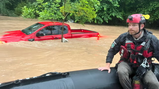
...The Flood Warning is extended for the following rivers inLouisiana...Texas...Bayou Anacoco Near RosepineSabine River Near Bon Wier...The Flood Warning continues for the following rivers inLouisiana...Texas...Bundick Creek At Bundick LakeCalcasieu River Near GlenmoraCalcasieu River near White Oak ParkCalcasieu River Near Salt Water BarrierSabine River Near DeweyvilleNeches River Near EvadaleNeches River Near Town BluffNeches River at Neches River Saltwater BarrierVillage Creek Near KountzePine Island Bayou Near Sour LakeAdditional information is available at www.weather.gov.The next statement will be issued Friday evening at 900 PM CDT.* WHAT...Moderate flooding is occurring and moderate flooding isforecast.* WHERE...Sabine River near Deweyville.* WHEN...Until further notice.* IMPACTS...At 26.8 feet, Deweyville schools may be closed due toschool bus routes being flooded.* ADDITIONAL DETAILS...- At 7:45 PM CDT Thursday the stage was 26.2 feet.- Recent Activity...The maximum river stage in the 24 hoursending at 7:45 PM CDT Thursday was 26.2 feet.- Forecast...The river is expected to rise to a crest of 26.5feet early tomorrow afternoon.- Flood stage is 24.0 feet.- http://www.weather.gov/safety/flood
...The Flood Warning is extended for the following rivers inLouisiana...Texas...Bayou Anacoco Near RosepineSabine River Near Bon Wier...The Flood Warning continues for the following rivers inLouisiana...Texas...Bundick Creek At Bundick LakeCalcasieu River Near GlenmoraCalcasieu River near White Oak ParkCalcasieu River Near Salt Water BarrierSabine River Near DeweyvilleNeches River Near EvadaleNeches River Near Town BluffNeches River at Neches River Saltwater BarrierVillage Creek Near KountzePine Island Bayou Near Sour LakeAdditional information is available at www.weather.gov.The next statement will be issued Friday evening at 900 PM CDT.* WHAT...Minor flooding is occurring and minor flooding is forecast.* WHERE...Calcasieu River near White Oak Park.* WHEN...Until further notice.* IMPACTS...At 3.0 feet, Water over lowest portions of Goos FerryRoad. Cars should be moved to higher ground.* ADDITIONAL DETAILS...- At 8:15 PM CDT Thursday the stage was 2.6 feet.- Recent Activity...The maximum river stage in the 24 hoursending at 8:15 PM CDT Thursday was 2.6 feet.- Forecast...The river is expected to rise to a crest of 2.7feet just after midnight tonight.- Flood stage is 2.0 feet.- http://www.weather.gov/safety/flood