Alertes en vigueurScottsville, TX
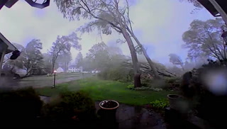
SEVERE THUNDERSTORM WATCH 222 REMAINS VALID UNTIL 11 PM CDT THISEVENING FOR THE FOLLOWING AREASIN ARKANSAS THIS WATCH INCLUDES 9 COUNTIESIN SOUTH CENTRAL ARKANSASUNIONIN SOUTHWEST ARKANSASCOLUMBIA HEMPSTEAD HOWARDLAFAYETTE LITTLE RIVER MILLERNEVADA SEVIERIN LOUISIANA THIS WATCH INCLUDES 9 PARISHESIN NORTH CENTRAL LOUISIANAJACKSON LINCOLN OUACHITAUNIONIN NORTHWEST LOUISIANABIENVILLE BOSSIER CADDOCLAIBORNE WEBSTERIN OKLAHOMA THIS WATCH INCLUDES 1 COUNTYIN SOUTHEAST OKLAHOMAMCCURTAININ TEXAS THIS WATCH INCLUDES 13 COUNTIESIN NORTHEAST TEXASBOWIE CAMP CASSFRANKLIN GREGG HARRISONMARION MORRIS RED RIVERSMITH TITUS UPSHURWOODTHIS INCLUDES THE CITIES OF ARCADIA, ASHDOWN, ATLANTA, BERNICE,BIG SANDY, BOGATA, BOSSIER CITY, BRADLEY, BROKEN BOW,CLARKSVILLE, DAINGERFIELD, DE QUEEN, DIERKS, EL DORADO,FARMERVILLE, GIBSLAND, GILMER, HAWKINS, HAYNESVILLE, HOMER, HOPE,HUGHES SPRINGS, IDABEL, JEFFERSON, JONESBORO, LEWISVILLE, LINDEN,LONE STAR, LONGVIEW, MAGNOLIA, MARSHALL, MINDEN, MINEOLA,MINERAL SPRINGS, MONROE, MOUNT PLEASANT, MOUNT VERNON, NAPLES,NASHVILLE, OMAHA, PITTSBURG, PRESCOTT, QUEEN CITY, QUITMAN,RINGGOLD, RUSTON, SHREVEPORT, SPRINGHILL, STAMPS, TEXARKANA,TEXARKANA, TYLER, AND WINNSBORO.
Do not drive cars through flooded areas.Caution is urged when walking near riverbanks.Turn around, don't drown when encountering flooded roads. Most flooddeaths occur in vehicles.Motorists should not attempt to drive around barricades or drivecars through flooded areas.For more hydrologic information, copy and paste the following websiteaddress into your favorite web browser URL bar:water.weather.gov/ahps2/index.php?wfo=shvThe next statement will be issued Friday morning at 830 AM CDT.
...The Flood Warning continues for the following rivers in Texas...Sabine River Near Beckville affecting Harrison, Rusk, Gregg andPanola Counties.Sabine River At Longview affecting Rusk and Gregg Counties.Sabine River Near Mineola affecting Smith and Wood Counties.Sabine River Near Gladewater affecting Smith, Gregg, Upshur andWood Counties.Sabine River Near Hawkins affecting Smith, Upshur and WoodCounties.For the Sabine River...including Mineola, Hawkins, Gladewater,Longview, Beckville...Moderate flooding is forecast.* WHAT...Minor flooding is occurring and minor flooding is forecast.* WHERE...Sabine River near Beckville.* WHEN...Until further notice.* IMPACTS...At 28.0 feet, Expect considerable lowland flooding onthe reach of the Sabine River from the Tatum through Beckville andDeBerry areas with flooded boat ramps, gas and petroleum wells,and even some low area cabins.* ADDITIONAL DETAILS...- At 7:45 AM CDT Thursday the stage was 27.4 feet.- Bankfull stage is 25.0 feet.- Recent Activity...The maximum river stage in the 24 hoursending at 7:45 AM CDT Thursday was 27.4 feet.- Forecast...The river is expected to rise to a crest of 27.8feet early Saturday afternoon.- Flood stage is 26.0 feet.- Flood History...This crest compares to a previous crest of27.8 feet on 03/12/2015.- http://www.weather.gov/safety/flood