Alertes en vigueurSand Hill, TX
Do not drive cars through flooded areas.Caution is urged when walking near riverbanks.Turn around, don't drown when encountering flooded roads. Most flooddeaths occur in vehicles.Motorists should not attempt to drive around barricades or drivecars through flooded areas.For more hydrologic information, copy and paste the following websiteaddress into your favorite web browser URL bar:water.weather.gov/ahps2/index.php?wfo=shvThe next statement will be issued Friday morning at 830 AM CDT.
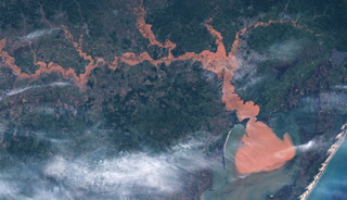
...The Flood Warning continues for the following rivers in Texas...Sabine River Near Beckville affecting Harrison, Rusk, Gregg andPanola Counties.Sabine River At Longview affecting Rusk and Gregg Counties.Sabine River Near Mineola affecting Smith and Wood Counties.Sabine River Near Gladewater affecting Smith, Gregg, Upshur andWood Counties.Sabine River Near Hawkins affecting Smith, Upshur and WoodCounties.For the Sabine River...including Mineola, Hawkins, Gladewater,Longview, Beckville...Moderate flooding is forecast.* WHAT...Minor flooding is occurring and minor flooding is forecast.* WHERE...Sabine River near Hawkins.* WHEN...Until further notice.* IMPACTS...At 25.0 feet, Minor lowland flooding of pastures andboatramps. Move livestock and equipment to higher ground.* ADDITIONAL DETAILS...- At 7:45 AM CDT Thursday the stage was 25.4 feet.- Bankfull stage is 22.0 feet.- Recent Activity...The maximum river stage in the 24 hoursending at 7:45 AM CDT Thursday was 26.1 feet.- Forecast...The river is expected to rise to a crest of 26.4feet Saturday evening.- Flood stage is 23.0 feet.- Flood History...This crest compares to a previous crest of27.1 feet on 03/25/2012.- http://www.weather.gov/safety/flood