Alertes en vigueurHarrells, TX
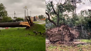
...The Flood Warning continues for the following rivers in Texas...Louisiana...Sabine River Near BurkevilleVillage Creek Near KountzeBayou Des Cannes Near EuniceBundick Creek At Bundick LakeWhisky Chitto Creek Near MittieBayou Nezpique Near BasileMermentau River Near MermentauSabine River Near Bon WierSabine River Near DeweyvilleNeches River Near EvadaleNeches River Near Town BluffNeches River at Neches River Saltwater BarrierPine Island Bayou Near Sour LakeAdditional information is available at www.weather.gov.The next statement will be issued Monday afternoon at 145 PM CDT.* WHAT...Moderate flooding is occurring and moderate flooding isforecast.* WHERE...Sabine River near Deweyville.* WHEN...Until further notice.* IMPACTS...At 27.9 feet, This flooding will be similar to theflooding expierenced in the flood of March 2001. Homes inDeweyville have water in them.* ADDITIONAL DETAILS...- At 12:45 PM CDT Sunday the stage was 27.6 feet.- Recent Activity...The maximum river stage in the 24 hoursending at 12:45 PM CDT Sunday was 27.6 feet.- Forecast...The river is expected to rise to a crest of 27.6feet this evening.- Flood stage is 24.0 feet.- http://www.weather.gov/safety/flood
...The Flood Warning continues for the following rivers in Texas...Louisiana...Sabine River Near BurkevilleVillage Creek Near KountzeBayou Des Cannes Near EuniceBundick Creek At Bundick LakeWhisky Chitto Creek Near MittieBayou Nezpique Near BasileMermentau River Near MermentauSabine River Near Bon WierSabine River Near DeweyvilleNeches River Near EvadaleNeches River Near Town BluffNeches River at Neches River Saltwater BarrierPine Island Bayou Near Sour LakeAdditional information is available at www.weather.gov.The next statement will be issued Monday afternoon at 145 PM CDT.* WHAT...Minor flooding is occurring and minor flooding is forecast.* WHERE...Sabine River near Burkeville.* WHEN...Until Tuesday evening.* IMPACTS...At 36.0 feet, Residential flooding in the River BendSubdivision occurs.* ADDITIONAL DETAILS...- At 1:15 PM CDT Sunday the stage was 37.0 feet.- Recent Activity...The maximum river stage in the 24 hoursending at 1:15 PM CDT Sunday was 37.2 feet.- Forecast...The river is expected to fall below flood stageTuesday morning and continue falling to 31.4 feet earlyFriday afternoon.- Flood stage is 36.0 feet.- http://www.weather.gov/safety/flood