Alertes en vigueurFannett, TX
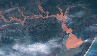
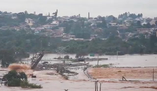
...The Flood Warning is extended for the following rivers in Texas...Village Creek Near KountzePine Island Bayou Near Sour Lake...The Flood Warning continues for the following rivers inLouisiana...Texas...Calcasieu River Near GlenmoraCalcasieu River near White Oak ParkSabine River Near Bon WierSabine River Near DeweyvilleNeches River Near EvadaleNeches River Near Town BluffNeches River at Neches River Saltwater Barrier...The Flood Warning is cancelled for the following rivers inLouisiana...Texas...Sabine River Near BurkevilleAdditional information is available at www.weather.gov.The next statement will be issued as needed. this evening at 930 PMCDT.* WHAT...Major flooding is occurring and major flooding is forecast.* WHERE...Neches River at Neches River Saltwater Barrier.* WHEN...Until further notice.* IMPACTS...At 10.0 feet, Major flooding along the river includingNorthwest Orange County From Lake View to the Saltwater Barrierwith several homes and camps flooded. Flooding is also occurringalong the river in Beaumont with major flooding at Colliers FerryPark and around the Beaumont Country Club. Residential roads offof Pine Street are impassable and water up to homes. Severalstreets in Northeast Beaumont also become flooded.* ADDITIONAL DETAILS...- At 7:15 PM CDT Wednesday the stage was 9.9 feet.- Recent Activity...The maximum river stage in the 24 hoursending at 7:15 PM CDT Wednesday was 10.3 feet.- Forecast...The river is expected to fall to 7.8 feet Mondayevening.- Flood stage is 4.0 feet.- http://www.weather.gov/safety/flood