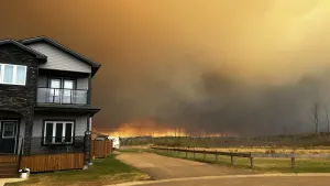
Alertes en vigueurBois D'arc, TX
Do not drive cars through flooded areas.Caution is urged when walking near riverbanks.Turn around, don't drown when encountering flooded roads. Most flooddeaths occur in vehicles.Motorists should not attempt to drive around barricades or drivecars through flooded areas.For more hydrologic information, copy and paste the following websiteaddress into your favorite web browser URL bar:water.weather.gov/ahps2/index.php?wfo=shvThe next statement will be issued Thursday morning at 1100 AM CDT.
...The Flood Warning is extended for the following rivers in Texas...Neches River Near Alto affecting Trinity, Cherokee, Houston andAnderson Counties....The Flood Warning continues for the following rivers in Texas...Neches River At Rockland affecting Angelina, Jasper, Tyler andPolk Counties.Neches River Near Diboll affecting Trinity, Angelina, Polk, Tylerand Houston Counties.Neches River Near Neches affecting Cherokee, Houston and AndersonCounties.For the Neches River...including Neches, Alto, Diboll, Rockland...Moderate flooding is forecast.* WHAT...Moderate flooding is occurring and moderate flooding isforecast.* WHERE...Neches River near Alto.* WHEN...Until further notice.* IMPACTS...At 19.0 feet, Preparations should be completed for amoderate flood. Barns and farm buildings near the river will bethreatened by high water. In addition, ranchers should havecompleted moving cattle and equipment to higher ground.* ADDITIONAL DETAILS...- At 10:15 AM CDT Wednesday the stage was 18.6 feet.- Bankfull stage is 16.0 feet.- Recent Activity...The maximum river stage in the 24 hoursending at 10:15 AM CDT Wednesday was 19.6 feet.- Forecast...The river is expected to fall to 16.5 feet Mondaymorning.- Flood stage is 16.0 feet.- Flood History...This crest compares to a previous crest of18.5 feet on 06/17/2016.- http://www.weather.gov/safety/flood
Do not drive cars through flooded areas.Caution is urged when walking near riverbanks.Turn around, don't drown when encountering flooded roads. Most flooddeaths occur in vehicles.Motorists should not attempt to drive around barricades or drivecars through flooded areas.For more hydrologic information, copy and paste the following websiteaddress into your favorite web browser URL bar:water.weather.gov/ahps2/index.php?wfo=shvThe next statement will be issued Thursday morning at 1100 AM CDT.
...The Flood Warning is extended for the following rivers in Texas...Neches River Near Alto affecting Trinity, Cherokee, Houston andAnderson Counties....The Flood Warning continues for the following rivers in Texas...Neches River At Rockland affecting Angelina, Jasper, Tyler andPolk Counties.Neches River Near Diboll affecting Trinity, Angelina, Polk, Tylerand Houston Counties.Neches River Near Neches affecting Cherokee, Houston and AndersonCounties.For the Neches River...including Neches, Alto, Diboll, Rockland...Moderate flooding is forecast.* WHAT...Minor flooding is occurring and minor flooding is forecast.* WHERE...Neches River near Neches.* WHEN...Until further notice.* IMPACTS...At 14.0 feet, Minor lowland flooding. Move livestockand equipment to higher ground away from the river.* ADDITIONAL DETAILS...- At 10:30 AM CDT Wednesday the stage was 14.0 feet.- Bankfull stage is 12.0 feet.- Recent Activity...The maximum river stage in the 24 hoursending at 10:30 AM CDT Wednesday was 14.2 feet.- Forecast...The river is expected to fall to 12.8 feet Mondaymorning.- Flood stage is 12.0 feet.- Flood History...This crest compares to a previous crest of14.0 feet on 12/28/2013.- http://www.weather.gov/safety/flood