Alertes en vigueurBrookside, PA
If outdoors, consider seeking shelter inside a building.A 10 to 15 minute period of torrential rain will accompany thesestorms and may lead to localized poor drainage flooding. Do notdrive your vehicle through flooded roadways.These storms will gradually intensify, so be certain to monitorlocal radio stations and available television stations foradditional information and possible warnings from the NationalWeather Service.Persons in campgrounds should consider seeking sturdy shelter untilthese storms pass.
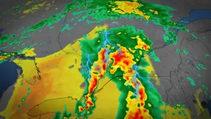
At 1202 PM EDT, Doppler radar was tracking a developing, broken lineof strong thunderstorms extending from 14 miles southeast ofWellsboro to near Milton to near Shamokin to Annville. Movement wasnortheast at 50 mph.HAZARD...Wind gusts up to 50 mph and pea size hail.SOURCE...Radar indicated.IMPACT...Gusty winds could knock down tree limbs and blow aroundunsecured objects. Minor hail damage to vegetation ispossible.Locations impacted include...Williamsport, Bloomsburg, Pottsville, Berwick, Sunbury, Shamokin,Tamaqua, Milton, Mount Carmel, Schuylkill Haven, Shenandoah,Danville, Montoursville, Minersville, Mahanoy City, Frackville,Northumberland, St. Clair, Kulpmont, and Ashland.