Alertes en vigueurSumter, NE
Bulletin Météorologique Spécial
Émis à mar. 23:06 mai. 14
Publié par : National Weather Service
Action Recommandée
If outdoors, consider seeking shelter inside a building.
Description
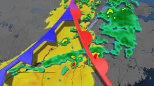
At 1106 PM CDT, Doppler radar was tracking strong thunderstorms alonga line extending from 8 miles west of Spalding to near Arcadia to 7miles southwest of Ansley. Movement was southeast at 25 mph.HAZARD...Wind gusts up to 50 mph and pea size hail.SOURCE...Radar indicated.IMPACT...Gusty winds could knock down tree limbs and blow aroundunsecured objects. Minor hail damage to vegetation ispossible.Strong thunderstorms will be near...North Loup around 1110 PM CDT.Greeley, Greeley Center, and Scotia around 1115 PM CDT.Loup City around 1120 PM CDT.Sherman Reservoir Dam around 1125 PM CDT.Other locations in the path of these storms include Litchfield.
Plus de nouvelles de MétéoMédia


Publicité
Publicité
Publicité