Alertes en vigueurOak Ridge, MO
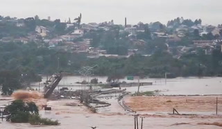
Turn around, don't drown when encountering flooded roads. Many flooddeaths occur in vehicles.Caution is urged when walking near riverbanks.Additional information is available at www.weather.gov.Thursday evening at 815 PM CDT.
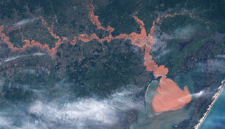
...The Flood Warning continues for the following rivers inMissouri...Little Osage River near Horton affecting Vernon County.Marmaton River near Nevada affecting Vernon County....The Flood Warning is extended for the following rivers inMissouri...Osage River at Taberville affecting Vernon and St. Clair Counties.For the Little Osage River...including Fulton, Horton...Minorflooding is forecast.For the Marmaton River...including Fort Scott, Nevada...Minorflooding is forecast.For the Osage River...including Taberville...Minor flooding isforecast.* WHAT...Minor flooding is occurring and minor flooding is forecast.* WHERE...Osage River at Taberville.* WHEN...Until further notice.* IMPACTS...At 29.0 feet, flood waters impact B Highway 2.5 mileseast of Rich Hill in the vicinity of the Bates County DrainageDitch.* ADDITIONAL DETAILS...- At 7:45 PM CDT Wednesday the stage was 29.5 feet.- Bankfull stage is 23.0 feet.- Recent Activity...The maximum river stage in the 24 hoursending at 7:45 PM CDT Wednesday was 30.5 feet.- Forecast...The river is expected to fall to 23.1 feet Mondayevening.- Flood stage is 23.0 feet.- http://www.weather.gov/safety/flood
Turn around, don't drown when encountering flooded roads. Many flooddeaths occur in vehicles.Caution is urged when walking near riverbanks.Additional information is available at www.weather.gov.Thursday evening at 815 PM CDT.
...The Flood Warning continues for the following rivers inMissouri...Little Osage River near Horton affecting Vernon County.Marmaton River near Nevada affecting Vernon County....The Flood Warning is extended for the following rivers inMissouri...Osage River at Taberville affecting Vernon and St. Clair Counties.For the Little Osage River...including Fulton, Horton...Minorflooding is forecast.For the Marmaton River...including Fort Scott, Nevada...Minorflooding is forecast.For the Osage River...including Taberville...Minor flooding isforecast.* WHAT...Minor flooding is occurring and minor flooding is forecast.* WHERE...Little Osage River near Horton.* WHEN...Until Saturday morning.* IMPACTS...At 45.0 feet, moderate flooding occurs at the gage site.Low lying areas along Route D near Stotesbury flood.* ADDITIONAL DETAILS...- At 7:45 PM CDT Wednesday the stage was 43.4 feet.- Bankfull stage is 41.0 feet.- Recent Activity...The maximum river stage in the 24 hoursending at 7:45 PM CDT Wednesday was 43.4 feet.- Forecast...The river is expected to fall below flood stageFriday morning and continue falling to 31.4 feet Mondayevening.- Flood stage is 41.0 feet.- http://www.weather.gov/safety/flood