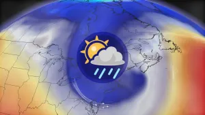
Alertes en vigueurCobb, MO
Caution is urged when walking near riverbanks.Turn around, don't drown when encountering flooded roads. Many flooddeaths occur in vehicles.Additional information is available at www.weather.gov.The next statement will be issued Friday morning at 845 AM CDT.
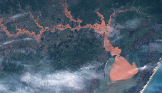
...The Flood Warning is extended for the following rivers inMissouri...Little Osage River near Horton affecting Vernon County.Marmaton River near Nevada affecting Vernon County....The Flood Warning continues for the following rivers inMissouri...Osage River at Taberville affecting Vernon and St. Clair Counties.For the Little Osage River...including Horton...Minor flooding isforecast.For the Marmaton River...including Nevada...Minor flooding isforecast.For the Osage River...including Taberville...Minor flooding isforecast.* WHAT...Minor flooding is occurring and minor flooding is forecast.* WHERE...Osage River at Taberville.* WHEN...Until early Wednesday morning.* IMPACTS...At 29.0 feet, flood waters impact B Highway 2.5 mileseast of Rich Hill in the vicinity of the Bates County DrainageDitch.* ADDITIONAL DETAILS...- At 7:45 AM CDT Thursday the stage was 29.1 feet.- Bankfull stage is 23.0 feet.- Recent Activity...The maximum river stage in the 24 hoursending at 7:45 AM CDT Thursday was 29.9 feet.- Forecast...The river is expected to fall below flood stageearly Tuesday morning and continue falling to 22.8 feetTuesday morning.- Flood stage is 23.0 feet.- Flood History...This crest compares to a previous crest of29.5 feet on 06/02/2015.- http://www.weather.gov/safety/flood