Alertes en vigueurRock Hill, MS
Bulletin météorologique spécial
Émis à jeu. 03:06 mai. 23
Publié par : National Weather Service
Action Recommandée
For your protection move to an interior room on the lowest floor of abuilding.
Description
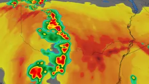
At 305 AM CDT, severe thunderstorms were located along a lineextending from near Jackson to near Harrisville to near Beauregard,moving east at 60 mph.HAZARD...60 mph wind gusts.SOURCE...Radar indicated.IMPACT...Expect damage to roofs, siding, and trees.These severe storms will be near...Jackson, Richland, Florence, D'Lo, Georgetown, Braxton, Pinola,Rockport, Oma, and Star around 310 AM CDT.Mendenhall, Cato, and Shivers around 315 AM CDT.New Hebron, Puckett, Johns, Sanatorium, and Martinville around 320AM CDT.Magee and White Oak around 325 AM CDT.Polkville and Clem around 330 AM CDT.
Plus de nouvelles de MétéoMédia


Publicité
Publicité
Publicité