Alertes en vigueurLockhart, LA
You should monitor later forecasts and be alert for possible FloodWarnings. Those living in areas prone to flooding should be preparedto take action should flooding develop.
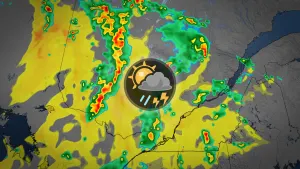
* WHAT...Flooding caused by excessive rainfall continues to bepossible.* WHERE...Portions of southeast Louisiana, including the followingparishes, Central Tangipahoa, East Baton Rouge, East Feliciana,Eastern Ascension, Eastern Orleans, Iberville, Lower Tangipahoa,Northern Livingston, Northern St. Tammany, Northern Tangipahoa,Southeast St. Tammany, Southern Livingston, Southwestern St.Tammany, St. Charles, St. Helena, St. James, St. John The Baptist,Upper Jefferson, Upper Plaquemines, Upper St. Bernard, Washington,West Baton Rouge, Western Ascension and Western Orleans andsouthern Mississippi, including the following areas, NorthernHancock, Northern Harrison, Northern Jackson, Pearl River,Southern Hancock, Southern Harrison and Southern Jackson.* WHEN...Through Saturday morning.* IMPACTS...Excessive runoff may result in flooding of rivers,creeks, streams, and other low-lying and flood-prone locations.Flooding may occur in poor drainage and urban areas.* ADDITIONAL DETAILS...- Thunderstorms capable of producing heavy rainfall will bemoving through the area again this afternoon. The risk forheavy rainfall and flash flooding increases overnight intoSaturday morning especially in areas that received heavyrainfall and poor drainage areas. An additional 1 to 3 inchesof rainfall with locally higher amounts will be possible.- http://www.weather.gov/safety/flood