Alertes en vigueurShipley, IA
You should monitor later forecasts and be prepared to take actionshould Flash Flood Warnings be issued.For the latest river and stream observations and forecasts refer toweather.gov/desmoines/water.
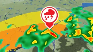
* WHAT...Flash flooding caused by excessive rainfall continues to bepossible.* WHERE...Much of central Iowa.* WHEN...Until 7 PM CDT this evening.* IMPACTS...Excessive runoff may result in flooding of rivers,creeks, streams, and other low-lying and flood-prone locations.Flooding may occur in poor drainage and urban areas.* ADDITIONAL DETAILS...- Rainfall of 3 to 5 inches with isolated higher amounts fellover parts of central Iowa last night into this morning andled to flash flooding in some areas. Additional round ofstorms is expected this afternoon that may cause new flashflooding or prolong or renew flash flooding in areas thatexperienced flash flooding earlier.
For the latest river and stream observations and forecasts refer toweather.gov/desmoines/water.Turn around, don't drown when encountering flooded roads. Most flooddeaths occur in vehicles.
* WHAT...Flooding caused by excessive rainfall continues.* WHERE...Portions of central, north central, and northeast Iowa,including the following counties, in central Iowa, Grundy, Hardin,Jasper, Marshall, Polk, Poweshiek, Story and Tama. In northcentral Iowa, Butler and Franklin. In northeast Iowa, Black Hawkand Bremer.* WHEN...Until 1115 PM CDT Tuesday.* IMPACTS...Flooding of rivers, creeks, streams, and other low-lyingand flood-prone locations is imminent or occurring. Numerous roadsremain closed due to flooding. Streams continue to rise due toexcess runoff from earlier rainfall. It will take several hoursfor all the water from these storms to work through local drainagesystems in urban areas.* ADDITIONAL DETAILS...- At 425 PM CDT, Emergency management reported ongoing floodingacross the warned area. Several road closures, road washoutsand isolated landslides have been reported. Additionalrainfall of around 1 inch over the next few hours may lead torenewed, additional or worse flooding.