Alertes en vigueurSchaller, IA
You should monitor later forecasts and be prepared to take actionshould Flash Flood Warnings be issued.For the latest river and stream observations and forecasts refer toweather.gov/desmoines/water.
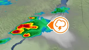
* WHAT...Flash flooding caused by excessive rainfall continues to bepossible.* WHERE...Portions of central, north central, northeast, northwest,south central, southwest, and west central Iowa, including thefollowing counties, in central Iowa, Boone, Dallas, Grundy,Hamilton, Hardin, Jasper, Marshall, Polk, Poweshiek, Story, Tamaand Webster. In north central Iowa, Butler, Cerro Gordo, Franklin,Hancock, Humboldt, Kossuth, Winnebago, Worth and Wright. Innortheast Iowa, Black Hawk and Bremer. In northwest Iowa, Emmet,Palo Alto and Pocahontas. In south central Iowa, Madison, Mahaska,Marion and Warren. In southwest Iowa, Adair and Cass. In westcentral Iowa, Audubon, Calhoun, Carroll, Crawford, Greene, Guthrieand Sac.* WHEN...Through this evening.* IMPACTS...Excessive runoff may result in flooding of rivers,creeks, streams, and other low-lying and flood-prone locations.Flooding may occur in poor drainage and urban areas.* ADDITIONAL DETAILS...- 3 to 5 inches of rain have already fallen over portions ofnorthern and north central Iowa. Slow moving storms withefficient rainfall rates will continue through the earlymorning hours, and could impact the morning commute.