Alertes en vigueurMcPaul, IA
TORNADO WATCH 276 REMAINS VALID UNTIL 5 PM CDT THIS AFTERNOON FORTHE FOLLOWING AREASIN IOWA THIS WATCH INCLUDES 8 COUNTIESIN SOUTHWEST IOWAFREMONT HARRISON MILLSMONTGOMERY PAGE POTTAWATTAMIESHELBYIN WEST CENTRAL IOWAMONONAIN NEBRASKA THIS WATCH INCLUDES 8 COUNTIESIN EAST CENTRAL NEBRASKABURT DOUGLAS SARPYWASHINGTONIN SOUTHEAST NEBRASKACASS NEMAHA OTOERICHARDSONTHIS INCLUDES THE CITIES OF AUBURN, BELLEVUE, BLAIR, CLARINDA,COUNCIL BLUFFS, DECATUR, DUNLAP, FALLS CITY, FARRAGUT, GLENWOOD,HAMBURG, HARLAN, LA VISTA, LOGAN, LYONS, MAPLETON,MISSOURI VALLEY, NEBRASKA CITY, OAKLAND, OMAHA, ONAWA, PAPILLION,PLATTSMOUTH, RED OAK, SHENANDOAH, SIDNEY, TABOR, TEKAMAH,AND WOODBINE.
Turn around, don't drown when encountering flooded roads. Most flooddeaths occur in vehicles.Additional information is available at water.weather.gov.The next statement will be issued late tonight at 115 AM CDT.
...The National Weather Service in Omaha/Valley NE has issued aFlood Warning for the following rivers in Nebraska...Iowa...Missouri...Big Blue River Near Seward affecting Seward County.Missouri River at Plattsmouth affecting Cass and Mills Counties.Missouri River At Nebraska City affecting Otoe and FremontCounties.Missouri River At Brownville affecting Nemaha and AtchisonCounties.West Nishnabotna River At Hancock affecting Pottawattamie County.West Nishnabotna River At Randolph affecting Mills and FremontCounties.* WHAT...Minor flooding is forecast.* WHERE...Missouri River at Nebraska City.* WHEN...From late tonight to late Friday evening.* IMPACTS...At 20.0 feet, Though flooding is already ongoing, thisis the level when flooding starts becoming more impactful,especially to agricultural areas.* ADDITIONAL DETAILS...- At 9:00 AM CDT Tuesday the stage was 12.4 feet...or 5.6 feetbelow flood stage.- Bankfull stage is 18.0 feet.- Forecast...The river is expected to rise above flood stagelate tonight to a crest of 20.5 feet tomorrow evening. Itwill then fall below flood stage Friday afternoon.- Flood stage is 18.0 feet.- http://www.weather.gov/safety/flood
Turn around, don't drown when encountering flooded roads. Most flooddeaths occur in vehicles.Additional information is available at water.weather.gov.The next statement will be issued late tonight at 115 AM CDT.
...The National Weather Service in Omaha/Valley NE has issued aFlood Warning for the following rivers in Nebraska...Iowa...Missouri...Big Blue River Near Seward affecting Seward County.Missouri River at Plattsmouth affecting Cass and Mills Counties.Missouri River At Nebraska City affecting Otoe and FremontCounties.Missouri River At Brownville affecting Nemaha and AtchisonCounties.West Nishnabotna River At Hancock affecting Pottawattamie County.West Nishnabotna River At Randolph affecting Mills and FremontCounties.* WHAT...Moderate flooding is forecast. This approaches the flood ofrecord.* WHERE...West Nishnabotna River at Randolph.* WHEN...From late tonight to early Friday morning.* IMPACTS...At 23.0 feet, County road J18 (120th Street) west ofRandolph begins to flood.* ADDITIONAL DETAILS...- At 9:00 AM CDT Tuesday the stage was 8.3 feet...or 10.7 feetbelow flood stage.- Bankfull stage is 19.0 feet.- Forecast...The river is expected to rise above flood stagejust after midnight tonight to a crest of 23.5 feet earlytomorrow afternoon. It will then fall below flood stageThursday morning.- Flood stage is 19.0 feet.- http://www.weather.gov/safety/flood
You should monitor later forecasts and be alert for possible FloodWarnings. Those living in areas prone to flooding should be preparedto take action should flooding develop.
* WHAT...Flooding caused by excessive rainfall continues to bepossible.* WHERE...Portions of Iowa, including the following counties,Fremont, Harrison, Mills, Monona, Montgomery, Page, Pottawattamieand Shelby and Nebraska, including the following counties, Cass,Douglas, Otoe, Sarpy and Washington.* WHEN...Until 7 PM CDT this evening.* IMPACTS...Excessive runoff may result in flooding of rivers,creeks, streams, and other low-lying and flood-prone locations.* ADDITIONAL DETAILS...- A line of thunderstorms continues to move through the area,but will be ending within the next 1 to 2 hours.- http://www.weather.gov/safety/flood
TAKE COVER NOW! Move to a basement or an interior room on the lowestfloor of a sturdy building. Avoid windows. If you are outdoors, in amobile home, or in a vehicle, move to the closest substantial shelterand protect yourself from flying debris.
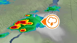
At 152 PM CDT, a severe thunderstorm capable of producing a tornadowas located 4 miles southeast of Beaver Lake, or 14 miles north ofNebraska City, moving northeast at 50 mph.HAZARD...Tornado and golf ball size hail.SOURCE...Radar indicated rotation.IMPACT...Flying debris will be dangerous to those caught withoutshelter. Mobile homes will be damaged or destroyed. Damageto roofs, windows, and vehicles will occur. Tree damage islikely.This dangerous storm will be near...Tabor around 155 PM CDT.Other locations in the path of this tornadic thunderstorm includeMalvern and Hastings.