Alertes en vigueurBessmay, TX
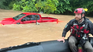
You should monitor later forecasts and be alert for possible FloodWarnings. Those living in areas prone to flooding should be preparedto take action should flooding develop.
* WHAT...Flooding caused by excessive rainfall is possible.* WHERE...A portion of southeast Texas, including the followingareas, Hardin, Lower Jefferson, Northern Jasper, Northern Newton,Northern Orange, Southern Jasper, Southern Newton, SouthernOrange, Tyler and Upper Jefferson.* WHEN...Through Sunday evening.* IMPACTS...Excessive runoff may result in flooding of rivers,creeks, streams, and other low-lying and flood-prone locations.* ADDITIONAL DETAILS...- Another round of showers and storms is expected to move overthe region tonight into Sunday. Showers and storms will becapable of producing heavy rainfall and high rainfall rates.Additional rainfall totals of 1 to 3 inches are expected withlocalized amounts up to 6 inches possible. This activity willmove over areas already saturated from heavy rainfall overthe past several days, and will exacerbate ongoing floodingacross the area.- http://www.weather.gov/safety/flood
Do not drive cars through flooded areas.Caution is urged when walking near riverbanks.Turn around, don't drown when encountering flooded roads. Most flooddeaths occur in vehicles.Caution is urged when walking near riverbanks.For more hydrologic information, copy and paste the following websiteaddress into your favorite web browser URL bar:water.weather.gov/ahps2/index.php?wfo=shvThe next statement will be issued Sunday evening at 1000 PM CDT.
...The Flood Warning continues for the following rivers in Texas...Neches River At Rockland affecting Jasper, Angelina, Polk andTyler Counties.Neches River Near Diboll affecting Houston, Tyler, Angelina,Trinity and Polk Counties.Neches River Near Alto affecting Trinity, Cherokee, Anderson andHouston Counties.For the Neches River...including Lake Palestine, Neches, Alto,Diboll, Rockland...Moderate flooding is forecast.* WHAT...Minor flooding is occurring and minor flooding is forecast.* WHERE...Neches River at Rockland.* WHEN...Until further notice.* IMPACTS...At 30.0 feet, High water will flood and close severalroadways especially in the Fox Landing community. Some low areahomes in the Fox Landing community will also be threatened withflooding.* ADDITIONAL DETAILS...- At 9:00 PM CDT Saturday the stage was 29.2 feet.- Bankfull stage is 28.0 feet.- Recent Activity...The maximum river stage in the 24 hoursending at 9:00 PM CDT Saturday was 29.2 feet.- Forecast...The river is expected to rise to a crest of 29.8feet Tuesday morning.- Flood stage is 26.0 feet.- Flood History...This crest compares to a previous crest of29.8 feet on 04/26/1926.- http://www.weather.gov/safety/flood
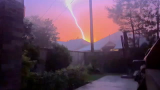
Torrential rainfall is also occurring with this storm and may lead tolocalized flooding. Do not drive your vehicle through floodedroadways.Frequent cloud to ground lightning is occurring with this storm.Lightning can strike 10 miles away from a thunderstorm. Seek a safeshelter inside a building or vehicle.
At 329 AM CDT, Doppler radar was tracking a strong thunderstorm overBevil Oaks, or 7 miles southwest of Lumberton, moving northeast at 35mph.HAZARD...Nickel size hail.SOURCE...Radar indicated.IMPACT...Minor damage to vegetation and outdoor objects is possible.Locations impacted include...Beaumont, Lumberton, Silsbee, Evadale, Bevil Oaks, Pine Forest,Lakeview, Weiss Bluff, and Gist.