Alertes en vigueurCedar Springs, MO
Turn around, don't drown when encountering flooded roads. Many flooddeaths occur in vehicles.
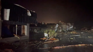
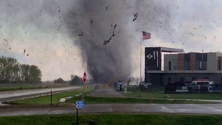
* WHAT...Flooding caused by excessive rainfall is expected.* WHERE...Portions of central, southwest, and west central Missouri,including the following counties, in central Missouri, Benton,Camden, Hickory, Miller and Morgan. In southwest Missouri, Cedar,Dallas and Polk. In west central Missouri, St. Clair.* WHEN...Until 1045 AM CDT Monday.* IMPACTS...Flooding of rivers, creeks, streams, and other low-lyingand flood-prone locations is imminent or occurring.* ADDITIONAL DETAILS...- At 1038 PM CDT, Local law enforcement reported heavy rain inthe warned area due to thunderstorms. Flooding is alreadyoccurring. Between 2 and 5 inches of rain have fallen.- This includes the following low water crossings...Saline Creek at Square Line Road, Wet Glaize at Carrol CaveRoad, Dry Auglaize Creek at Freedom Ridge Road, LittleNiangua at County Road 200, Lindley Creek at Mathis Road,Brush Creek at 1200 Road and Weaubleau Creek at 350 Road.- Some locations that will experience flooding include...Bolivar, Eldon, Osage Beach, Camdenton, El Dorado Springs,Buffalo, Versailles, Warsaw, Stockton, Hermitage, Village ofFour Seasons, Lake Ozark, Lincoln, Appleton City, Cole Camp,Stover, Humansville, Osceola, Laurie, Conway, Iberia, LowryCity, Pleasant Hope, Fair Play, Weaubleau, Urbana,Morrisville, Wheatland, Macks Creek, Pittsburg, Polk, SunriseBeach, St. Elizabeth, Linn Creek, Jerico Springs, Preston,Cross Timbers, Barnett, Tuscumbia and Halfway.- http://www.weather.gov/safety/flood