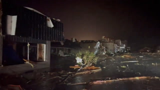
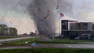
Alertes en vigueurBronaugh, MO
Be especially cautious at night when it is harder to recognize thedangers of flooding.Turn around, don't drown when encountering flooded roads. Many flooddeaths occur in vehicles.Additional information is available at www.weather.gov.The next statement will be issued Monday evening at 1015 PM CDT.
...The Flood Warning continues for the following rivers inMissouri...Kansas...Little Osage River near Horton affecting Vernon County.Little Osage River at Fulton affecting Bourbon County.Marmaton River at Fort Scott affecting Bourbon County.Osage River at Taberville affecting Vernon and St. Clair Counties....The Flood Warning is extended for the following rivers inMissouri...Marmaton River near Nevada affecting Vernon County.For the Little Osage River...including Fulton, Horton...Majorflooding is forecast.For the Marmaton River...including Fort Scott, Nevada...Majorflooding is forecast.For the Osage River...including Taberville...Moderate flooding isforecast.* WHAT...Minor flooding is occurring and major flooding is forecast.This approaches the flood of record.* WHERE...Marmaton River near Nevada.* WHEN...Until early Saturday morning.* IMPACTS...At 32.0 feet, flood waters affect portions of Highway 54between Deerfield and Nevada where Dry Wood Creek...Little DryWood Creek and the Marmaton meet west of Nevada.* ADDITIONAL DETAILS...- At 9:45 PM CDT Sunday the stage was 25.0 feet.- Bankfull stage is 20.0 feet.- Recent Activity...The maximum river stage in the 24 hoursending at 9:45 PM CDT Sunday was 25.0 feet.- Forecast...The river is expected to rise to a crest of 31.6feet early tomorrow afternoon. It will then fall below floodstage early Friday morning.- Flood stage is 20.0 feet.- Flood History...This crest compares to a previous crest of31.6 feet on 03/31/1980.- http://www.weather.gov/safety/flood
Be especially cautious at night when it is harder to recognize thedangers of flooding.Turn around, don't drown when encountering flooded roads. Many flooddeaths occur in vehicles.Additional information is available at www.weather.gov.The next statement will be issued Monday evening at 1015 PM CDT.
...The Flood Warning continues for the following rivers inMissouri...Kansas...Little Osage River near Horton affecting Vernon County.Little Osage River at Fulton affecting Bourbon County.Marmaton River at Fort Scott affecting Bourbon County.Osage River at Taberville affecting Vernon and St. Clair Counties....The Flood Warning is extended for the following rivers inMissouri...Marmaton River near Nevada affecting Vernon County.For the Little Osage River...including Fulton, Horton...Majorflooding is forecast.For the Marmaton River...including Fort Scott, Nevada...Majorflooding is forecast.For the Osage River...including Taberville...Moderate flooding isforecast.* WHAT...Major flooding is occurring and major flooding is forecast.* WHERE...Little Osage River near Horton.* WHEN...Until early Friday afternoon.* IMPACTS...At 53.0 feet, flood waters reach the bottom portion ofthe I-Beam along the U.S. Highway 71 bridge at the gage site,north of Horton.* ADDITIONAL DETAILS...- At 9:45 PM CDT Sunday the stage was 52.0 feet.- Bankfull stage is 41.0 feet.- Recent Activity...The maximum river stage in the 24 hoursending at 9:45 PM CDT Sunday was 52.0 feet.- Forecast...The river is expected to rise to a crest of 52.5feet just after midnight tonight. It will then fall belowflood stage early Thursday afternoon.- Flood stage is 41.0 feet.- Flood History...This crest compares to a previous crest of51.8 feet on 04/13/1994.- http://www.weather.gov/safety/flood
Be especially cautious at night when it is harder to recognize thedangers of flooding.Turn around, don't drown when encountering flooded roads. Many flooddeaths occur in vehicles.Additional information is available at www.weather.gov.The next statement will be issued Monday evening at 1015 PM CDT.
...The Flood Warning continues for the following rivers inMissouri...Kansas...Little Osage River near Horton affecting Vernon County.Little Osage River at Fulton affecting Bourbon County.Marmaton River at Fort Scott affecting Bourbon County.Osage River at Taberville affecting Vernon and St. Clair Counties....The Flood Warning is extended for the following rivers inMissouri...Marmaton River near Nevada affecting Vernon County.For the Little Osage River...including Fulton, Horton...Majorflooding is forecast.For the Marmaton River...including Fort Scott, Nevada...Majorflooding is forecast.For the Osage River...including Taberville...Moderate flooding isforecast.* WHAT...Minor flooding is occurring and moderate flooding isforecast.* WHERE...Osage River at Taberville.* WHEN...Until further notice.* IMPACTS...At 34.0 feet, Moderate Flood Stage. B Highway 2.5 mileseast of Rich Hill in the vicinity of the Bates County DrainageDitch is under several feet of water.* ADDITIONAL DETAILS...- At 9:45 PM CDT Sunday the stage was 24.8 feet.- Bankfull stage is 23.0 feet.- Recent Activity...The maximum river stage in the 24 hoursending at 9:45 PM CDT Sunday was 24.8 feet.- Forecast...The river is expected to rise to a crest of 34.8feet Wednesday morning.- Flood stage is 23.0 feet.- Flood History...This crest compares to a previous crest of36.1 feet on 05/04/2017.- http://www.weather.gov/safety/flood