Alertes en vigueurIndian Village, LA
You should monitor later forecasts and be prepared to take actionshould Flash Flood Warnings be issued.
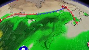
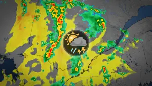
* WHAT...Flash flooding caused by excessive rainfall continues to bepossible.* WHERE...Portions of central, south central, and southwestLouisiana, including the following parishes, in central Louisiana,Avoyelles, Evangeline and St. Landry. In south central Louisiana,Lafayette and Upper St. Martin. In southwest Louisiana, Allen,Northern Acadia, Northern Calcasieu, Northern Jefferson Davis,Southern Acadia, Southern Calcasieu, Southern Jefferson Davis andUpper Vermilion.* WHEN...Through late tonight.* IMPACTS...Excessive runoff may result in flooding of rivers,creeks, streams, and other low-lying and flood-prone locations.Creeks and streams may rise out of their banks. Flooding may occurin poor drainage and urban areas.* ADDITIONAL DETAILS...- Another round of showers and thunderstorms is forecast thisafternoon into evening. Any additional rainfall falling overlocations with saturated grounds, along with high flows alongarea creeks, bayous, and drainage ditches, will bring aboutan increased risk of flash flooding.- http://www.weather.gov/safety/flood
...The Flood Warning is extended for the following rivers inLouisiana...Bayou Nezpique Near BasileFor the Bayou Nezpique...including Basile...Minor flooding isforecast.Additional information is available at www.weather.gov.The next statement will be issued Saturday morning at 1015 AM CDT.* WHAT...Minor flooding is forecast.* WHERE...Bayou Nezpique near Basile.* WHEN...From Saturday morning until further notice.* IMPACTS...At 22.0 feet, Minor agricultural flood damage will occur.* ADDITIONAL DETAILS...- At 9:15 AM CDT Friday the stage was 21.3 feet.- Forecast...The river is expected to rise above flood stagelate tomorrow morning and continue rising to 23.0 feetTuesday morning. Additional rises are possible thereafter.- Flood stage is 22.0 feet.- http://www.weather.gov/safety/flood